All published articles of this journal are available on ScienceDirect.

State of the Art on the Contributions and Use of Geographic Information Systems (GIS) in Epidemiology in Morocco
Abstract
Background
The Geographic Information System (GIS) plays a significant role in the healthcare information system. The use of GIS as an epidemiological research tool is very little known in Morocco. According to the Moroccan Ministry of Health's Health Plan for 2025, axis 23 aims to complete the deployment of the decision support information system through the implementation of the geographic information system with the goal of improving governance and optimizing resource allocation. This creates constraints in achieving the design of an appropriate GIS for modeling pathologies using remote sensing and spatial statistical methods. The current work aims to understand GIS and its applications in epidemiology, with a focus on the state of scientific knowledge related to GIS in epidemiological research.
Methods
A state-of-the-art review of the various uses of GIS in epidemiological research was conducted using several university databases, such as PubMed and Scopus, recent articles, and certain reference books, focusing on the following keywords: “utilization,” “GIS,” and “epidemiology,” as well as their synonyms identified by MeSH.
Results
The majority of GIS research applied to epidemiology primarily involves making observations using GIS, which are then incorporated into action plans to promote population health. Therefore, it is important to break down the aspects of GIS (Geographic Information System) usage in epidemiology into four components. These include epidemiological surveillance, determining primary healthcare needs, healthcare planning, and healthcare quality.
Conclusion
These results clearly demonstrate the significant contribution of GIS to the improvement of public health. However, there is a need for positive action regarding the integration of this system, especially in developing countries.
1. INTRODUCTION
The Geographic Information System (GIS) plays a significant role in the healthcare information system [1]. The Geographic Information System (GIS) is a powerful tool used in various fields, including epidemiology [2]. Epidemiology is the study of the causes, distribution, and control of diseases in specific populations. Thanks to the combination of geographical data and epidemiological data, GIS enables researchers and healthcare professionals to better understand the patterns of disease spread, identify at-risk populations, and make well-informed decisions regarding prevention and treatment [3].
The overall purpose of this study is to explore the contributions and uses of Geographic Information Systems (GIS) in epidemiology. We will seek to demonstrate how GIS can improve disease surveillance, intervention planning, and decision-making in the field of public health. In this regard, we will conduct a review of the contributions and uses of Geographic Information Systems (GIS) in epidemiology.
The Geographic Information System (GIS) has become a powerful catalyst in the healthcare information system, fundamentally changing how we gather, analyze, and present data to guide public health decision-making [1]. GIS has demonstrated its immense value in comprehending the spatial arrangement of illnesses, pinpointing variables that contribute to risk, and monitoring patterns of disease, thereby facilitating effective interventions and enhancing health outcomes for the population [2].
GIS is crucial in the field of epidemiology since it greatly improves disease surveillance, intervention planning, and decision-making [3]. Through the integration of illness data and geographical information, Geographic Information System (GIS) empowers academics and healthcare practitioners to:
1.1. Monitor the Transmission of Contagious Illnesses
Geographic Information Systems (GIS) offer up-to-date analysis on the geographical dispersion of infections, facilitating prompt identification of epidemics, pinpointing areas of high infection rates, and guiding focused containment strategies.
1.2. Identify Vulnerable Populations
Geographic Information Systems (GIS) allow for the visualization and analysis of demographic, social, and environmental variables that contribute to the likelihood of illness occurrence. This helps in determining the most urgent treatments and addressing inequalities in health outcomes.
1.3. Arrange Successful Interventions
GIS-based analysis can help allocate healthcare resources so that interventions are focused on the regions that most require them and that resource use is optimized.
1.4. Evaluate the Effectiveness of Interventions with GIS
It can be used to track their effects and pinpoint locations that benefit from more adaption or improvement as well as those that do not.
1.5. Make Wise Choices
From developing policies to providing services, GIS offers evidence-based insights to assist decision-making at every stage of the healthcare system.
The incorporation of Geographic Information Systems (GIS) into the field of epidemiological research and practice has resulted in notable progress in the domain of public health. GIS has played a crucial role in monitoring the transmission of contagious illnesses, including HIV/AIDS, malaria, and Ebola, facilitating the implementation of efficient containment strategies in addition to averting large-scale epidemics. Furthermore, Geographic Information Systems (GIS) have been employed to evaluate the allocation of healthcare resources, pinpoint locations with inadequate services, and provide valuable insights for focused initiatives aimed at enhancing healthcare accessibility.
Even though GIS has proven to be quite valuable in epidemiology, underdeveloped nations like Morocco are still not using it to much of an extent. It is critical to solve the issues raised, such as a lack of GIS competence, data gaps, and inadequate infrastructure, in order to properly utilize GIS in Morocco's epidemiological landscape. Morocco can establish itself as a leader in GIS-driven epidemiological research and practice by addressing these obstacles and putting the advice into practice, thereby improving the health of its people.
2. MATERIALS AND METHODS
A thorough literature study was carried out in order to give an overview of the current state of knowledge about GIS applications in epidemiology. A profound search was conducted using reputable web resources, current publications, and pertinent reference books, in addition to large university databases like PubMed and Scopus. The MeSH synonyms for the terms “utilization,” “GIS,” and “epidemiology” were also included in the search method. Furthermore, it was thought that grey literature, which includes official documents and white papers, fully reflected the range of GIS uses in epidemiology.
In the interest of finding studies that concentrated on the use of GIS in epidemiological research, a comprehensive screening of full-text publications, abstracts, and titles was part of the literature review process. After that, a critical assessment of the chosen research was conducted to determine the methodological rigor, conclusions, and significance for the development of GIS-based epidemiology.
A full-scale review process ensured that the article encompassed the most recent and pertinent research on GIS applications in epidemiology, giving readers a solid basis for comprehending the field's present state of knowledge and pointing out potential directions for further investigation.
3. CURRENT STATE OF KNOWLEDGE ON THE SUBJECT
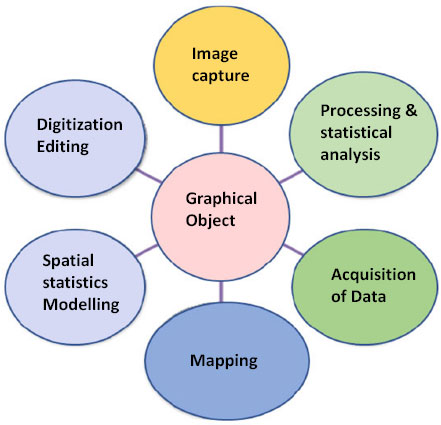
In 1854, John Snow created a map showing the cholera outbreak in London, England, specifically in the Soho district of London in 1854 [4]. Through this map, he was able to provide visual information about the distribution of the patients and where they were getting their water from. He determined that it was the water from a specific well that was the source of contamination. It was the beginning of the use of Geographic Information Systems (GIS) in epidemiology [5]. Today, GIS is experiencing unprecedented growth and enables precise location tracking in addition to offering powerful analytical capabilities [6]. It allows for the creation, storage, analysis, and display of data, including a geographic component (which provides information about their location) [7] (Fig. 1). Interactive maps based on geographic information science provide valuable insights for public health to study disease prevalence [8]. Indeed, public health draws upon a variety of diverse and complementary disciplines: epidemiological, social, and economic medicine, and incorporates various concepts, such as environment, history, and culture [9]. It encompasses all dimensions of care: preventive, curative, educational, as well as rehabilitative [10]. Geographic Information Systems (GIS) add a very important graphical and analytical dimension to public health by bringing together the fundamental triad of epidemiology, namely, the person, the time, and the place [7].
Most writings on the subject only focus on the “computer tool” dimension, while others incorporate the dimension of information production and decision-making. In general, GIS enables the collection and storage, visualization, overlay, querying, and analysis of georeferenced data [11].
In the field of healthcare, GIS allows for the study of spatial dynamics to explain certain health phenomena [2]. Professionals in this field are expected to understand the correlation between determinants and health phenomena; GIS and associated technologies, such as remote sensing, are increasingly being used to analyze the geography of diseases, particularly the relationships between pathological factors (causal agents, vectors, hosts, individuals) along with their geographical environment [12].
The majority of GIS research applied to epidemiology primarily involves conducting observations using GIS, which are then incorporated into action plans to promote public health [13]. Moreover, other authors have addressed the contributions of GIS related to healthcare management and the promotion of population health [14]. Indeed, the use of GIS to address public health issues has experienced exponential growth [15]. This system has effectively contributed to the evaluation and treatment of health problems at the international level [16].
The use of GIS and disease mapping is rapidly growing, as these diseases are being linked to the environment and healthcare infrastructure [17, 18]. As a result, the geographic information generated is a powerful tool for monitoring and managing public health priorities [19]. The recent development in geospatial technologies enables the creation of maps with spatial and temporal data relevant to health planning, implementation, and research [20]. Geographical questions have become increasingly relevant for research and public health policies, especially through the lens of geographic information systems (GIS) [2].
3.1. GIS Applications in Epidemiology: Concrete Examples
3.1.1. COVID-19 Response
The COVID-19 pandemic posed a global challenge to public health [21], prompting the use of spatial analysis and GIS to provide decision-making tools, predictive models, and statistical methods for epidemic control [22]. In Morocco, GIS played a crucial role in addressing the pandemic, identifying high-risk areas, and enhancing the epidemiological surveillance system [1]. However, limitations like data unavailability and bias, along with scarcity in demographic, environmental, and socio-economic data, hindered the in-depth exploration of causal relationships [23].
3.2. Diverse Applications Beyond Pandemics
GIS applications extend beyond pandemics, including road accident analysis and road design for accident prevention [24]. Additionally, GIS and remote sensing are essential in waste management modeling [25], offering transformative insights into ecological causes of evolutionary patterns [18]. GIS, particularly using ArcGIS software, aids in spatial analysis of infant mortality variations [26], as well as thematic mapping guides preventive measures and control strategies against diseases like dengue fever [27].
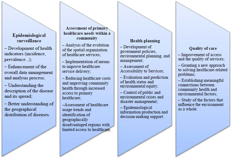
Understanding the diverse applications of GIS in epidemiology requires a closer look at its specific aspects. Fig. (2) illustrates four key aspects:
3.2.1. Epidemiological Surveillance
GIS plays a pivotal role in tracking and monitoring the spread of diseases, enhancing epidemiological surveillance. It aids in early detection, response planning, and resource allocation during outbreaks [1, 3, 22, 23].
3.2.2. Assessment of Primary Healthcare Needs within a Community
GIS assists in evaluating primary healthcare needs by analyzing spatial dynamics. It aids in identifying areas with specific health requirements, supporting targeted interventions and resource allocation [5, 8, 24].
3.2.3. Health Planning
GIS contributes to health planning by providing insights into disease prevalence, vulnerable populations, and healthcare infrastructure. It promotes informed decision-making for strategic health interventions [16].
3.2.4. Quality of Care
GIS contributes to the quality of care by helping in disease mapping, linking diseases to environmental factors, and enabling effective healthcare management [15].
Despite the importance of GIS in epidemiology, it is challenging to model the spatial aspect of disease evolution without resorting to spatial statistics [28]. The design and implementation of a GIS require good preliminary preparation. We must analyze the data already acquired and to be acquired, the stakeholders (production, processing, information management, and data exchange), and the expectations. The GIS pertains more specifically to national disease control measures [29].
On the other hand, despite the existence of more powerful software than GIS for designing phenomena, GIS considers itself as a design support tool [16]. Thus, GIS serves as the foundation for a data management process aimed at periodically updating a database. Moreover, three major uses can be associated with GIS. It is primarily a means to consult maps and visualize the territory, as well as a tool for knowledge and observation [30].
3.3. GIS Use in Morocco and Global Context
Despite GIS's significance in epidemiology, its use as a research tool is poorly known in Morocco [31]. A 2015 study in Meknes, Morocco, using spatial statistical techniques combined with GIS, marked a significant contribution to understanding the distribution of typhoid fever identifying risk factors to support local authorities in combating the disease [10]. Geospatial techniques are vital for measuring, analyzing, and modeling climate change in addition to its effects on human health [32].
Aligned with the Moroccan Ministry of Health's 2025 Plan, Axis 23 aims to deploy a geographic information system to improve governance and optimize resource allocation for disease modeling, utilizing remote sensing and spatial statistics [33].
3.4. GIS, Big Data, and Environmental Research
As environmental research enters the era of Big Data [34], GIS and Big Data refine epidemiological disease estimates for specific communities [35]. GIS meets epidemic demands and aids in designing prevention and control strategies [36], becoming a valuable technology across diverse fields [37]. GIS complements conventional ecological monitoring and modeling, providing a means to describe complex relationships in disease ecology [38]. Its main advantage lies in graphically displaying different area attributes in an easily interpretable way [39]. Database research, geographic information systems, and disease prevention education are essential tools in disease prevention [40].
CONCLUSION
In conclusion, this state-of-the-art review delving into the applications of GIS in epidemiology underscores the numerous advantages that GIS brings to the forefront, significantly contributing to the enhancement of public health. The central role of GIS lies in its digital scrutiny of disease distribution and environmental factors. Noteworthy advantages include its prowess in effectively visualizing and communicating data, expediting the identification of spatial patterns and epidemic hotspots, as well as bolstering intervention planning.
Despite these advantages, it is imperative to acknowledge certain limitations inherent in GIS applications. Ethical considerations surrounding the use of geographical data, safeguarding individual data privacy, and technological constraints, such as the availability of computer resources and accessibility of GIS software, need careful consideration. An essential aspect of maximizing GIS efficacy is the comprehensive training of healthcare professionals. This training equips them to adeptly collect, manage, and analyze geographical data, thereby harnessing the full potential of GIS in epidemiological research.
Looking forward, the integration of surveillance systems that amalgamate epidemiological and geographical data emerges as a critical stride toward a more nuanced comprehension of disease transmission patterns. Such integrated systems pave the way for evidence-based decision-making, providing a robust foundation for addressing public health challenges. In essence, the judicious use of GIS, coupled with continuous professional development and innovative integrated surveillance, holds the promise of advancing epidemiological research and ultimately improving public health outcomes.
ABBREVIATION
| GIS | Geographic Information System |
CONSENT FOR PUBLICATION
Not applicable.
AVAILABILITY OF DATA AND MATERIALS
The data supporting the findings of this study were obtained from literature searches of public databases like PubMed and Scopus. No individual dataset was used.
FUNDING
None.
CONFLICT OF INTEREST
The authors declare no conflict of interest, financial or otherwise.
ACKNOWLEDGEMENTS
Declared none.